Waves and Swell
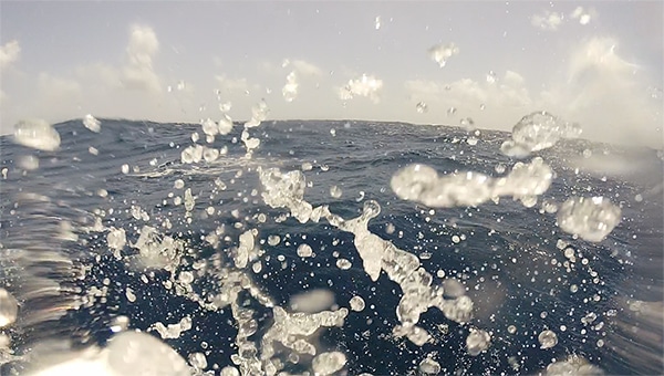
Waves, Photo Taken in Martinique
Since it is a good idea to keep your boat on top of the water, it’s good to understand the dynamics of water. Thus waves is a big topic when it comes to safe boating and weather.
Waves
Waves on the ocean are primarily generated by wind blowing across the water’s surface. As the wind transfers energy to the water, it creates waves, with their characteristics influenced by several key factors.
Factors Affecting Wave Height, Length, and Steepness
Wind Speed: Stronger winds transfer more energy to the water, leading to taller waves.
Wind Duration: The longer the wind blows steadily in one direction, the larger the waves can grow.
Fetch: This is the distance over which the wind blows across the water. A longer fetch allows waves to accumulate more energy, resulting in greater height and longer wavelengths.
Wave Height, Length, and Steepness
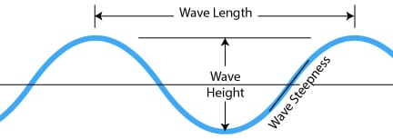
Wave Height: The vertical distance between a wave’s crest (the highest point) and trough (the lowest point). Higher wind speeds and longer fetches typically produce taller waves.
Wavelength: The horizontal distance between successive wave crests. Longer wavelengths develop when waves are exposed to sustained winds over a long fetch.
Wave Steepness: Defined as the ratio of wave height to wavelength (H/L). Wave steepness increases with higher wave heights and shorter wavelengths, making the waves sharper and more abrupt. Steepness is influenced by how much energy is packed into a wave over a short distance; stronger winds and shorter fetches often create steeper waves.
Transition to Swell
As waves move away from their area of generation, they begin to smooth out, with the shorter, choppier waves dissipating more quickly. The remaining waves, which have longer wavelengths and are less steep, continue to travel over long distances as swell.
Swell waves are typically more regular and can travel thousands of kilometers across the ocean, carrying the energy from distant storms. These swells arrive at distant shores, influencing coastal conditions and activities such as surfing and navigation, long after the winds that created them have ceased.
Practical Implications
Understanding wave dynamics, including wave height, length, and steepness, is crucial for safe boating and preventing seasickness.
1. Wave Height and Safe Boating
Stability and Handling: Taller steeper waves increase the likelihood of a vessel being tossed around, making it harder to maintain stability and control. Smaller boats are particularly vulnerable to capsizing in high waves. Boaters need to monitor wave height forecasts and avoid venturing out in conditions where waves exceed the safe handling limits of their vessel.
Water on Deck: High waves can result in water washing over the deck, which can be dangerous and cause damage. Vessels should be designed or equipped to handle the maximum expected wave height for their operational area.
2. Wave Length and Comfort
Motion Sickness: Longer waves generally create smoother and slower motions, reducing the likelihood of seasickness. Shorter waves, especially those that are choppy and irregular, can cause abrupt vertical and lateral movements, increasing the chance of seasickness.
Riding the Waves: Understanding wavelength helps in navigating waves more effectively. Longer waves allow for more predictable and manageable movements, while short waves require more skill to avoid jarring impacts and rolling dangers.
3. Wave Steepness and Safety
Steep waves cause more abrupt and intense vertical motion, which can significantly increase the likelihood of seasickness. Vertical acceleration is a primary factor in causing seasickness, particularly when it exceeds 0.2 to 0.5 meters per second squared (m/s²). This range is critical because the human body’s vestibular system—located in the inner ear—senses changes in motion and balance.
The vestibular system relies on the movement of fluid within the semicircular canals to detect changes in orientation and acceleration. When vertical accelerations are rapid and frequent, as in steep waves, the fluid in the inner ear moves unpredictably, causing confusion between what the eyes see and what the inner ear senses. This mismatch in sensory information can lead to nausea, dizziness, and other symptoms of seasickness.
In steep or choppy conditions where vertical accelerations frequently exceed this threshold, even seasoned mariners can experience discomfort. Therefore, understanding and anticipating vertical accelerations due to wave steepness can be critical for managing seasickness risk. Boaters can take measures such as slowing down, altering course, or using seasickness-prevention techniques when high vertical accelerations are expected.
|
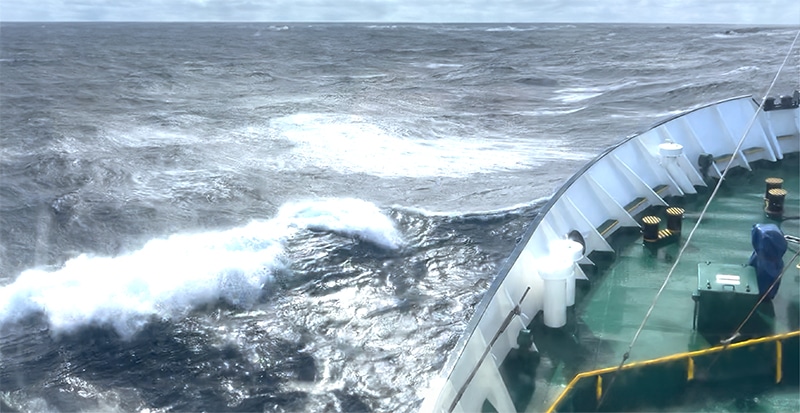
Anecdote of the Southern Ocean: I took this photo below in the Southern Ocean returning from Antarctica on an expedition ship. Two things to learn about this photo. (1) Photos never ever do the sea justice of what the conditions were really like. (2) It was rough – really rough. The captain recorded the highest wave at 25 ft (8m) and the largest roll angle at 43 degrees. 50% of the passengers were puking their eyeballs out because the vertical acceleration was up to 0.5m/s2. Still, not one person would have traded out this experience to not visit the Antarctic. It was amazing and so worth it. Me? I used an electric shocker band on my wrist on my acupressure point. No lunch was lost. My Luddite brother said that acupressure points are hokus pokus – while he took serious seasick drugs. Another friend reacted to hving too much scopolamine from double patching. She was convinced it was the morning and had gotten 12 hours of sleep when in reality she had only been away 15 minutes and it was still the evening. |
The Polar Explorer Thrashing Through 25 ft Seas
A seasick crew, including yourself, is a dangerous situation to be in. It results in poor judgment and poor decision making which can lead to disaster. Additionally, a crew member experiencing seasickness will vow to never go out with you again – especially a child.
4. Navigational Strategies
Course Adjustment: Boaters can adjust their course to take waves at an angle rather than head-on to reduce the impact and improve stability. Understanding wave dynamics allows for better decision-making in rough seas.
Timing and Route Planning: Avoiding areas known for high or steep waves, such as around headlands or during certain weather conditions, can improve safety and comfort. Route planning should account for wave forecasts to minimize exposure to dangerous conditions.
5. Safety Precautions
Monitoring Weather: Continuous monitoring of weather and sea state forecasts is essential to anticipate changes in wave dynamics. This allows for timely decisions, such as seeking shelter before conditions worsen.
Vessel Preparedness: Ensuring that the boat is equipped to handle expected wave conditions, including proper ballast, securing loose items, and ensuring that life jackets are readily available and worn, is critical for safety.
6. Seasickness Prevention
Positioning: Passengers prone to seasickness should stay in the center of the vessel, where motion is less intense, and focus on the horizon to reduce disorientation. We’ve also found that having a crewmember drive the boat will quickly cure seasickness.
Medication: Prophylactic use of seasickness medication can be helpful, especially if steep or irregular waves are expected. The electric wristband shocker really works!
For Fun
We created this video of boating in rough seas in our Virtual Reality Program. If you are faint of heart, best you don’t watch it and certainly don’t do it in VR. If you think you can handle it go ahead – then try it in VR if you have a MetaQuest Headset 3.
In summary, understanding wave dynamics, including height, length, and steepness, allows boaters to make informed decisions that enhance safety, improve comfort, and reduce the risk of seasickness. Proper planning, vessel handling, and passenger precautions are essential to navigating varying sea conditions safely.
Prediction of Wave Dynamics
The ability to predict wave height, length, and steepness has advanced significantly in recent years due to improvements in meteorological and oceanographic technology. Modern wave prediction relies on a combination of satellite observations, buoy data, and sophisticated computer models that simulate ocean conditions.
It is hard to grasp, but with technology and data analysis, we have access to real-time wave data just about all over the planet. This allows us to predict wave data up to a week in the future. Various available Apps can be used by mariners to gain access to predicted and real-time wave dynamics. One such app is Predict Wind.
How We Get the Data
1. Satellite Observations
Global Coverage: Satellites equipped with radar altimeters can measure wave height across vast areas of the ocean with high accuracy. These instruments send radar pulses down to the sea surface and measure the time it takes for the pulses to return, providing data on sea surface height and wave characteristics.
Real-Time Data: Satellite data is available in near real-time, allowing for continuous monitoring of ocean conditions. This helps in tracking the development and movement of wave systems, particularly those generated by distant storms.
2. Buoy Networks
In-Situ Measurements: Ocean buoys are equipped with sensors that measure wave height, period, vertical acceleration, and direction directly from the water. This data is crucial for validating satellite observations and refining wave models.
Steepness Calculation: Buoy data can be used to calculate wave steepness by analyzing the ratio of wave height to wavelength. This is critical for assessing the potential impact on vessels and coastal areas.
3. Numerical Wave Models
Sophisticated Simulations: Modern wave models, such as the WaveWatch III and SWAN (Simulating WAves Nearshore), simulate the behavior of waves based on wind speed, direction, and duration. These models take into account the generation, propagation, and dissipation of waves over time.
Wave Height and Length Prediction: Models can accurately predict wave height and length based on the energy transfer from wind to water. They can forecast how waves will evolve as they travel across different oceanic conditions.
Steepness Forecasting: By simulating the interaction between wind and waves, these models can also predict wave steepness, which is crucial for understanding the potential risks to maritime operations.
4. Improved Weather Forecasting
Integrated Systems: Weather forecasting models now integrate atmospheric and oceanic data to predict how storms will generate and influence wave conditions. This integration improves the accuracy of predictions for wave height, length, and steepness.
Storm Tracking: Advanced weather models track storms and their wind fields, providing predictions on where and when wave systems will develop, their potential size, and how steep they might become.
5. Limitations and Ongoing Improvements
Resolution and Local Effects: While predictions have become very accurate on a large scale, local factors such as currents, tides, and coastal topography can still introduce variability. Continuous improvement in model resolution and local data integration is helping to address these challenges.
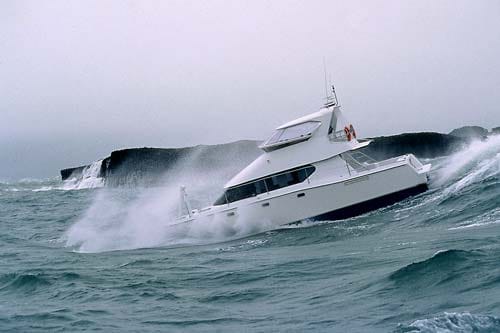
| Anecdote: A lesson learned from a fishing trip to the Great Barrier Island in New Zealand. The Great Barrier Island is an ideal place in the world – beaches, fishing, scallops! To get there from Auckland is about a 30-mile cruise across the ocean. One time we were having such an amazing time that we extended our weekend long trip. The weather had been settled and the risk seemed low to extend. On the way back in the later afternoon, the seas picked up to a point where we had to slow significantly. They continued to pick up to about a 2m (6 ft) state and quite steep. The slow speed meant darkness fell while we were still a long way out. The big waves meant getting wet. While all ended well – this is not ideal – and prudent decisions were not made. Lesson learned! |

