Understanding Wind
Winds can be gentle, hardly felt, like zephyrs flitting about in a local area, or they can be vast movements of air moving swiftly across oceans and continents at low and high altitudes.
Wind is measured most typically in knots. 10 knots is about 11.5 mph or about 20 km/hr (slightly less but 2 times is easy to remember). 10 knots is a decent and easily manageable wind strength creating only small waves with no white caps.
Wind forecast models are pretty good these days and can generally be relied upon. Note the “generally” and “pretty good” words in the last statement. Gusts can come seemingly from nowhere and conditions can change faster than predicted.
Below is an embedded real-time webpage frame from windy.com. Windy.com shows global wind and the forecast. Having a poke around it is quite interesting; you can zoom in and out, change location, and see what is predicted in the future.
Sea Breezes
Sea breezes are a local area scale of the effect of differential heating of air. They are well-known to experienced boaters and in particular – sailors.
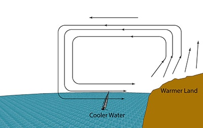
In the diagram below, a parcel of air over land in summer at noon will be warmed more than a parcel over water. Both receive the same amount of solar heat, but it takes more heat to raise water one degree than it does for land. Hence, the parcel over the warmer land will thus rise while the heavier cooler air over the water will flow in under it to take its place.
This phenomenon gives birth to the so-called daytime “sea breeze” where the air is coming from the sea towards the land.
Sea Breeze
The reverse occurs at night, particularly on clear nights when the Earth can radiate a lot of heat out to space. Now, the air warmed by the water rises and is replaced by the descending cooler air over the land driving the airflow in the reverse direction, creating a “land breeze”. This can surprise an unwary boater when as the night wears on and he sleeps at anchor, the land breeze alters the wind, and his boat swings in a new direction. Did he consider this effect when he anchored?
During daytime hours sea breezes can yield stiffer wind conditions just next to a coast, when there might be no wind further offshore and none otherwise shown in large-scale weather forecast models. Nowadays, local effects such as sea breezes are built into the weather prediction models and are shown in smaller-scale (local) weather forecasts.
Whether it is a sea breeze or just a regular wind direction, when the wind comes from the sea, the waves have a longer distance to pick up in height. When coming from land, waves will tend to be less in height closer to shore.
Surface Winds
Light surface winds produce “cat paw” looking waves, whereas stronger winds produce sharper and higher waves. As winds increase, energy is transferred to the water, waves become higher, and spray begins blowing off the crests of waves. Experienced sailors can often accurately determine wind speed by watching the waves. The first appearance of “White Caps” on the waves occurs at about 12 knots of wind.
Wind Symbols
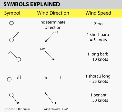
When reading a weather map or wind map you need to know the symbols used. Make sure you understand this table, especially the directions. The circles are the head of the arrow; the barbs are the tail. Take note, these are in the test to follow.
Wind Symbols Explained
In compass-named directions, the wind directions in the table above are:
- 5 knots north-easterly (the wind is coming FROM the north-east)
- 10 knots north-westerly
- 25 knots easterly
- 50 knots south-south-easterly
A common mistake is to think that the arrow is like a wind vane. It is not! The arrow points in the direction of the flow of the wind. The circle is the arrowhead – it’s the PC version of an arrow – it won’t hurt when it hits you.
Here is how to remember wind flow direction when quoted in a weather forecast. If you live in the northern hemisphere, you surely know that a northerly wind is bitterly cold – because it comes from the Arctic Circle – brrrr. That is, a Northerly wind comes FROM the North. For southern hemisphere people – you’ll know that a southerly wind is bitterly cold – because it comes from the Antarctic Circle – brrrr. That is, a Southerly wind comes FROM the South.
Beaufort Scale
The Beaufort Wind Scale is both historically and visually very interesting. It was designed by British Admiral Francis Beaufort in the 1830’s to help large, fully rigged vessels determine their sail requirements. While it is a classic number system, it is still used in wind forecasts but not much in North America when knots are predominantly used.
THE BEAUFORT WIND SCALE
| Force |
Wind
(Knots) |
WMO Classification |
Appearance of Wind Effects On the Water |
|---|---|---|---|
| 0 |
Less than 1
|
Calm | Sea surface smooth and mirror-like |
| 1 |
1-3
|
Light Air | Scaly ripples, no foam crests |
| 2 |
4-6
|
Light Breeze | Small wavelets, crests glassy, no breaking |
| 3 |
7-10
|
Gentle Breeze | Large wavelets, crests begin to break, scattered whitecaps |
| 4 |
11-16
|
Moderate Breeze | Small waves 1-4 ft. becoming longer, numerous whitecaps |
| 5 |
17-21
|
Fresh Breeze | Moderate waves 4-8 ft taking longer form, many whitecaps, some spray |
| 6 |
22-27
|
Strong Wind Warning | Larger waves 8-13 ft, whitecaps common, more spray |
| 7 |
28-33
|
Near Gale | Sea heaps up, waves 13-20 ft, white foam streaks off breakers |
| 8 |
34-40
|
Gale | Moderately high (13-20 ft) waves of greater length, edges of crests begin to break into spindrift, foam blown in streaks |
| 9 |
41-47
|
Strong Gale | High waves (20 ft), sea begins to roll, dense streaks of foam, spray may reduce visibility |
| 10 |
48-55
|
Storm | Very high waves (20-30 ft) with overhanging crests, sea white with densely blown foam, heavy rolling, lowered visibility |
| 11 |
56-63
|
Violent Storm | Exceptionally high (30-45 ft) waves, foam patches cover sea, visibility more reduced |
| 12 |
64+
|
Hurricane | Air filled with foam, waves over 45 ft, sea completely white with driving spray, visibility greatly reduced |
This is pretty hard to remember. Thus, look at the table above and remember the maximum wind conditions force number that you are comfortable boating in. If force conditions are reported as worse, then you know not to go out or to prepare if you are already out. Generally speaking, FORCE 4 is about the maximum comfort for most and anything above that is starting to get hairy! Remember Force FOUR is the maximum FOR going boating.
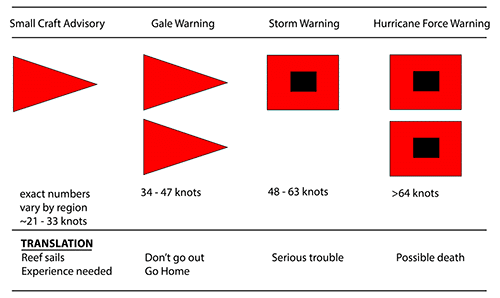
Yacht clubs and some harbormasters may fly flags to indicate any wind warnings. These are not internationally standardized so it is best you check for your country and state (yes, even states differ in the USA). Don’t go boating in anything above Small Craft Advisory and note that a Small Craft Advisory is a warning to those in small craft that conditions are dangerous. If you are inexperienced, you should not go out under small craft advisory conditions – even if you are in a big craft.
Here is a table of the most common wind warning flags in the USA, though some other countries also use them.
Wind Warning Flags
Gusts
Gusts can occur at virtually any time and can be extremely dangerous for several reasons.
- Pushing your boat into other boats especially while at anchor where all the boats will suddenly start moving and reacting in different manners
- Forces a change in the direction of your boat when maneuvering slowly. This is especially dangerous in a marina
- Causes your anchor to drag
- Can heel the boat over enough to make people and stuff fly around. This is especially true for a boat with a tall profile.
Gusts can be seen coming by a moving discoloration of the water. Good crew members point out approaching gusts to the skipper.
Here is a series of gusts in “The Bight” on Norman Island, British Virgin Islands.
Wind Gusts in the BVI
Here is a series of gusts created by Katabatic winds in the Marlborough Sounds, New Zealand.
Katabatic Wind Gusts
In General
Always keep in mind that you never want to allow the wind to overpower your vessel since this can lead to catastrophic results. As wind velocities increase, the force on a boat’s hull is dramatically increased by the squared power. For example: if the wind speed doubles from 5 knots to 10 knots, the force on the hull quadruples; from 5 knots to 20 knots, the force becomes 16 times greater.

